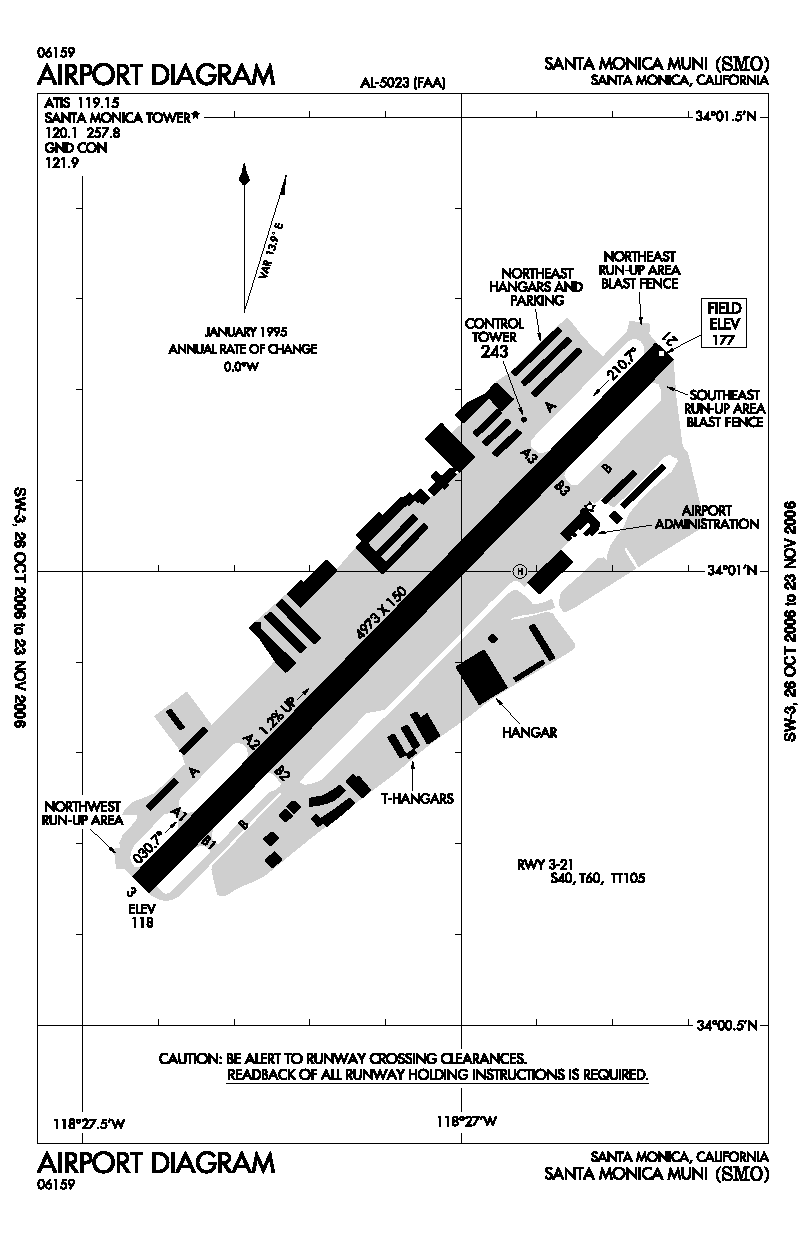
The source of this map is the wikipedia [www.wikipedia.org] article on Santa Monica Airport. The following is the link tothe image: [http://upload.wikimedia.org/wikipedia/commons/8/8a/SMO_-_FAA_airport_diagram.gif]. The original source of this image can be found on the FAA website [faa.gov] at [http://www.naco.faa.gov/index.asp?xml=naco/online/d_tpp]. This is the official FAA diagram of Santa Monica Airport, which is located in the south-eastern corner of the city of Santa Monica. This map shows the number of runways (only one), the dimensions of this runway, and its slope. In addition to this, the map reveals more accurate measurements of the runway heading, and the magnetic directions associated with it. Furthermore, the map labels and identifies the hangers and buildings found around Santa Monica Airport. The map is displayed on top of latitude and longitude lines down to the minute. Finally, the map labels taxiways and heliports. I find this map interesting because of my love of aviation and aeronautics. I think it's fascinating that a map so simple can convey so much information to pilots and air traffic controllers alike to safely and effectively operate aircraft at this airport. I also think that the amount of intricate detail in this map is quite interesting.

The source of this map is a website called type of words [typeofwords.com] at this url: [http://typeofwords.com/wp-content/uploads/2010/01/philadelphia_1842.jpg]. This map, which dates back a few dozen decades, shows the checkerboard-like layout of downtown Philadelphia, also known today as Center City. This map shows the bodies of water that border downtown Philly, the Schuykill and Delaware rivers, as well as many of the street names. A legend is given for the various abbreviations found on the map, and the harbors on the eastern side of the city are also labeled. A scale (in feet) is also given at the bottom of the map. Furthermore, the various parks scattered throughout the city known as "squares" are also labeled. This map is interesting to me because the majority of my family resides in Philadelphia, and I have spent a great deal of time there. I am familiar with its layout, and it is interesting to see it in this perspective. Additionally, the old age of this map only adds to my already exiting interest, as I have a fascination with all things ancient and archaic.
No comments:
Post a Comment